
The Moravian-Silesian Region has placed municipal territorial plans on the web
 |
"After the launch of this project, people just need to look at the website, where they will find all the information," he stated. He added that the electronic format of the spatial plans should also help the municipalities themselves. "The spatial plans in individual municipalities are interconnected, so the municipalities can see the spatial plans of the surrounding areas and thus they can align their spatial plans with those of neighboring municipalities; it is not necessary to go to that municipality," Vzientek noted.
The region has a total of 299 municipalities and towns; the 30 missing spatial plans are from municipalities that have not yet created these plans. These primarily concern municipalities with up to 500 inhabitants. "A municipality without a spatial plan cannot apply for money from the European Union, as one of the conditions is that the municipality must have a spatial plan," Vzientek stated. He added that the region has therefore released 10 million crowns from its budget this year, allowing small municipalities to obtain a subsidy for the creation of their spatial plans.
The spatial plans of municipalities that are yet to be created will also be made available on the internet later. The existing spatial plans should be updated approximately once every three months. According to the mayor of Třinec, Věra Palkovská, the availability of spatial plans on the internet will reduce the number of inquiries from citizens, who will already know, for example, whether they can build a family house on a selected plot. "People will be able to orient themselves more quickly," Palkovská stated.
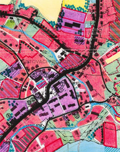
The region started working on making spatial plans available through the website in 2007. The entire project cost around 8.5 million crowns and was mainly financed through a grant from Norway, Iceland, and Liechtenstein. Nearly 28,000 drawings of spatial planning documentation and almost 70,000 pages of texts of generally binding regulations and other documents had to be converted into electronic format.
People can find the spatial plans for free on the website mapy.kr-moravskoslezsky.cz. The web application has also been made available to individual towns and municipalities.
The English translation is powered by AI tool. Switch to Czech to view the original text source.
2 comments
add comment
Subject
Author
Date
Skutečně plnohodnotné
alešjílek
09.04.09 08:41
uzemní plány
Marek
24.10.11 06:30
show all comments