Stopover plan Prague Airport

AEROPOLIS is an association of three architectural offices (rala, CMC, D3A) that was approached by the CAH / LP investor to develop a design for the zoning plan of the central part of Prague Airport Ruzyně. The architectural teams rala, CMC, and D3A are awarded finalists of the architectural-urban competition (2015) "Public Space in front of Terminals 1 and 2 at Václav Havel Airport Prague." From the mutual discussions of the studios and other workshops after the competition, the AEROPOLIS association emerged as a compact and strong design team.
The document Zoning Plan Part 1 AUDIT outlines a clear and critical overview of the traffic situation at LPR, the results of the competition for the public space in front of T1 and T2, and roughly illustrated examples of contemporary world airports. It focused on collecting and comparing information, which created a data foundation for Part 2 ANALYSIS, with the primary goal of accurately defining all aspects and properties of LPR and its operations. Within the document, three main categories of assessment were created - existing state, currently planned projects, and visions for the future. Each topic was supplemented by a fourth chapter "definition of requirements," resulting in the definition of the assignment for the design of the Zoning Plan. THE DESIGN of the Zoning Plan for LPR is a vision for the development of both commercial and non-commercial activities at Prague Airport Ruzyně over the next twenty to thirty years. The document consists of 13 chapters, in which the AEROPOLIS team elaborately processed various aspects of the design, from broader urban planning solutions to architectural details of selected public spaces, to addressing the development of transport and technical infrastructure.
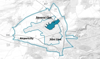
The CAH intention in AIRPORT CITY SEVER is to increase the value of the property while creating a platform for future expansion of the airport's capacity and ensuring commercial viability for the next thirty to forty years. The main goal of the Zoning Plan for Sever according to the Assignment was to design and prescribe a controlled, optimized, and sustainable development, encompassing technical and transport infrastructure as well as commercial and non-commercial buildings. Through implementing the Zoning Plan for Sever and its visions, CAH will maintain full control over Airport City - its growth, quality, character, phasing, and, last but not least, investment costs.
The final result of the Zoning Plan for Sever is a comprehensive and final planning document that will serve as a valuable tool in the future process of creating public-private partnerships (PPP) with national and international investors. The Zoning Plan for Sever outlines all necessary criteria for development, including business opportunities, physical and technical limitations, appropriate timing, or "critical paths" during the permitting process.
URBAN CONCEPT
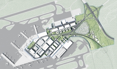
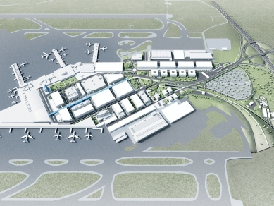
The urban concept of Airport City Sever has three basic zones - CENTER, SERVICE, and BUSINESS, along with a fourth supplementary zone GATE. These make up the structure and morphology of the area in axial configurations. All zones are interconnected and functionally linked directly or indirectly to the terminals. Essentially, three-quarters of the area of Airport City Sever creates a simple, logical, and functional synergy formed from various activities that are mostly interconnected with air traffic.
In terms of transportation, the train and its underground station are key factors in the future accessibility of Airport City Sever. The railway station is located on the central axis of the developed area, directly under the main promenade leading to the terminal spaces. The transportation system was divided into two circuits - public transport and the servicing of Airport City Sever CENTER, which is conducted at ground level, while personal car transport for passengers is separated on an extended and elevated structure. Ultimately, Airport City Sever should be perceived as a compact and sustainable destination connected with air traffic, a place with positive energy infused with greenery and modern buildings that is easily accessible.
DESIGN
Airport City Sever - CENTER
In the existing urbanism of the zone, the most notable element is the embryo of the "horseshoe" of Terminals 1 and 2 and its planned completion in the form of the expansion of Terminal 2 with finger D. Other significant urban elements include the configuration of existing large-scale buildings within the "horseshoe," the urban axis of the territory, Aviatická Street, which in its current form functions only as an airport departure, and the dominant element of the elevated roadway, which has a fundamental influence on the character and shaping of the surrounding space.
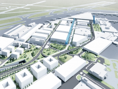
In designing the urbanism of this largest zone, we supported the main axis of Aviatická and proposed it as an urban pedestrian zone, densely filling the existing buildings along it. The axis is clearly defined on the east by newly designed hotel and congress center buildings and on the west by Terminal 2. The axis functions on three levels - underground is the railway station leading directly into Terminal 2, at ground level there is the aforementioned pedestrian zone, which in front of Terminal 2 leads into the public space between T2 and the new bus terminals, and finally, the upper floors feature the iconic spine building SKYWALK with shops and services at ground level, office spaces on the floor above, and moving walkways with resting platforms on the upper floor. SKYWALK will enable quick and convenient "dry-foot" connections between all destinations linked to the axis. In addition to the previously mentioned buildings of Terminal 2, the railway station, bus terminals, congress center, and hotels, there are also parking garages, car rental services, and administrative buildings. The axis continues in the eastern part as a park path with a bike path leading towards the BUSINESS and GATE zones. Separately from the axis, but connected to Terminal 1, a building of the Aviation Museum has been proposed, which should relate in its scale, proportions, and character to Hall T1 and create, together with the hotel and conference center, an "entrance gate" to the CENTER zone. To ensure clear and smooth transport, the operations in this zone were divided into two levels. At level +1, the elevated roadway was extended, which should primarily serve passengers and the servicing of T2, parking garages, and car rentals. At ground level is the city with streets, a pedestrian zone, and public spaces, where pedestrians, service traffic, public transport, charter, and long-distance buses operate.
In front of Terminals 1 and 2, a Public Space is proposed. The public space between airport Terminal 2 and the bus terminals is smaller and designed as a paved area with local greenery elements and equipped with urban furniture. It is a square with busy pedestrian and taxi traffic, while also offering places to rest and wait. A different type of public space is designed in front of Terminal 1, where a larger free area of park greenery has been retained as a contrast to the densely built-up character of this zone. The specific design of the public space will be the subject of future project phases, including the design of a smaller multifunctional refreshment facility.
Airport City Sever - SERVICE
The SERVICE zone currently does not exist and has been proposed as a new, clearly defined urban complex along the new communication axis in the southern part of the area, primarily to serve functions supporting the airport's operations. The SERVICE zone closely borders the CENTER zone, and thanks to the extended elevated roadway, easy passage between them is ensured by transitions at ground level/city. Along the new axial communication are large buildings of 2-6 floors depending on the proposed function. The axis is concluded on the west by the maneuvering area of the newly designed Terminal 2 expedition and catering buildings. The new communication/street is well accessible, visible, and creates space for a long waiting edge on both sides.
Airport City Sever - BUSINESS
The BUSINESS zone is formed as a third independent urban complex in the northern part of the area defined by the access road Aviatická and the CARGO terminals. The purpose of the zone is to centralize commercial-administrative functions with the possibility of utilizing proximity to the Cargo and SRA buildings. The BUSINESS zone, like the other zones, is multifunctional and the principle of linking buildings to a central communication axis has been applied here as well. Large-volume buildings of parking garages are proposed here, each occupying the area of an urban block, as well as smaller administrative buildings of a business park. Outside the axis, the new water tower and checkpoints on Aviatická Street and K Letišti Street are located. The zone is connected to the CENTER and SERVICE zones. For pedestrians and cyclists, a connection through the park and underpass under Aviatická Street has been proposed.
Airport City Sever - GATE
The Airport City GATE zone is generally defined to the north by Aviatická Street, to the east by the D7 highway, and to the south by K Letišti Street. Currently, there is a PH gas station here, which is planned to be relocated to the CENTER zone, and a SOUTH wastewater treatment plant, which will be retained. Within the design of the Zoning Plan, a large surface parking lot is proposed in the GATE area, linked to the newly constructed significant secondary connection between Aviatická Street and K Letišti Street, which also serves as a secondary connection between the BUSINESS and SERVICE zones. The construction of buildings has not been proposed in the zone due to the longer distance from the terminals and urbanized zones and the need for a large surface parking lot, for which placement further from the "center" is suitable.
The English translation is powered by AI tool. Switch to Czech to view the original text source.
0 comments
add comment


