

Humanization of the Prague magistrale in the section of Nusle Bridge and 5th of May Street
<Ideová studie>

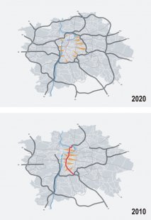
S-J boulevard is essentially a highway that cuts through the city. Its basic features include grade-separated intersections, underpasses and pedestrian overpasses, guardrails, noise barriers, fences, concrete curbs, and similar elements. As a superior route, it creates an insurmountable barrier in the area and degrades its surroundings through noise, emissions, vibrations, and dust. This otherwise significant connection within the city limits of Prague functions as a remnant of the former grid transportation system from the 1960s, which prioritized quick passage through Prague by car. The second, more sophisticated plan for Prague's basic communication system (ZAKOS) from the 1970s contributed to the S-J boulevard's present form. Only the urban plan from 1999 demanded its calming. This idea continues in the Strategic Plan of the City of Prague from 2002, which goes even further. It seeks ways to limit transportation capacity and aims to humanize the boulevard and transform it into a boulevard.
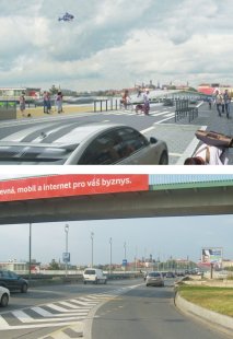
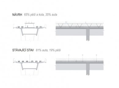
The current traffic intensity in the addressed section ranges between 82,000 and 88,000 vehicles daily. The humanization study anticipates reducing this intensity to approximately 40,000 vehicles a day, contingent upon meeting several conditions. Completion of the outer and inner ring road in Prague with a radial system, redevelopment of the "at Kačerov" intersection so that it primarily directs traffic from the D1 highway to the inner ring, creating new connections between neighborhoods via new bridges or exploring alternatives in a possibly denser traffic network, implementing a parking system along radial routes in relation to public transport, conceptual improvement of public transport, and introducing tolled entry onto the inner and outer ring roads.
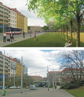
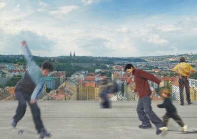
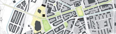
The fundamental idea of humanizing the boulevard became the concept of an urban boulevard characterized by both representational and residential elements. The goal is to design a lively street with shops, cafés, and restaurants, creating space for active movement of residents, children's play, or relaxation in green areas. At the same time, it aims to create a pleasant connection between the city center and the contemplated new modern hub of Prague in the Pankrácká plain area.
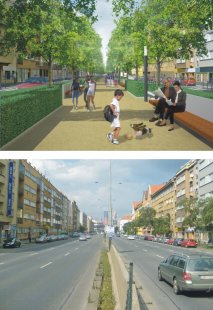
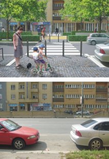
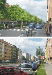
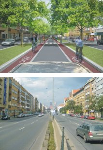
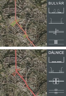
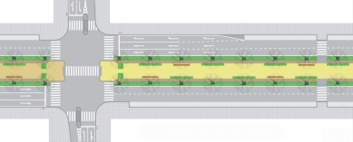
The design considers reducing the number of traffic lanes from 3+3 to 2+2 and narrowing the width of the lanes to a minimum. The wide asphalt area is divided by a 12.5-meter-wide central living area for pedestrians and cyclists, designed as a promenade with a crushed stone surface, equipped with furniture, sales pavilions, information stands, and small playgrounds. This is accompanied by two rows of tall-stemmed trees in a grassy strip and trimmed bushes. Conversely, automobile traffic is suppressed and divided into two more intimate spaces, with roads that naturally lead drivers to slower speeds. Sidewalks next to buildings are proposed to be 5 meters wide, where it is possible to situate restaurant and café terraces. Next to the sidewalk, longitudinal parking spaces are occasionally replaced with turn lanes.
The overall improvement of the environment on 5. května Street positively influences the surrounding public spaces, specifically Pankrácké náměstí, the area of Lounských Street, Náměstí Hrdinů, and prospectively the Arkády intersection.
The large area of Náměstí Hrdinů is topographically leveled, the grade-separated junction is changed to a level junction with traffic lights and pedestrian and cyclist crossings. The rediscovered rectangular figure of the square is supported by lining with trees and complemented by massing at the intersection of Na Pankráci and Lomnického streets. At the head of the square stands a monumental palace building of a public institution (the High Court), to which the boulevard will also conform. On one side, the square opens into a rectangular figure, while on the other, it closes back to its usual profile. The design anticipates relocating the tram depot with a loop to another, less prestigious part of the city. For traffic reasons, the tram route is dug below the entire area of the square, and the stop is newly placed near the vestibule of the Pražského povstání metro station, with which it is levelly connected.
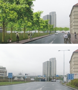
Pankrácké náměstí is the space between the Palace of Culture and the Pankrák blocks. The expansive area is now mainly constituted by a large grade-separated intersection with ramps and underpasses, large spiral ramps for entering underground garages, the Palace of Culture, and the adjacent Holiday Inn hotel. A certain rehabilitation of the place into its logical natural urban structure with level intersections and crossings is also proposed here. The streets trace the edges of the public space, and the created free area has the character of a tree park, complementing the existing solitary buildings in the vicinity. In front of the Palace of Culture, a pre-access street is proposed, leading directly from 5. května Avenue. Access to the underground garages will be ideologically considered from the perimeter of the park. The areas of the underpasses of the grade-separated intersection can be commercially utilized, for example, for the construction of underground garages.
By the Corinthia Hotel, there is an ideological consideration for building a new solitary building that would visually close the space of the new square.
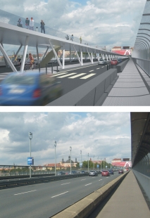
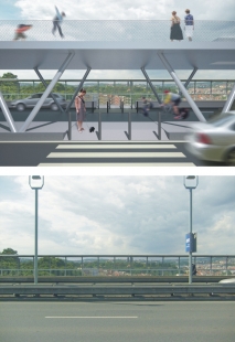
In the axis of the Nusle Bridge, an elevated structure is proposed for a pedestrian footbridge, serving as a lookout gallery or promenade, and it may also serve as a platform for artistic artifacts. The central living area of 5. května Street in front of the Nusle Bridge smoothly connects to this footbridge. A new exit from the Vyšehrad metro station is also situated in the central strip.
The second variant named ALTERNATING LANE is a sort of intermediary version (a middle step) between the main proposal and the existing state. This variant is based on fixed 2 + 2 traffic lanes and on an alternating lane, situated in the center of the street profile and serving in the morning peak towards the city and in the afternoon peak away from the city. Traffic would be controlled by intelligent traffic signals. Longitudinal parking spaces next to the sidewalks would be preserved. The alternating lane is surrounded on both sides by green strips, creating a tree alley. The connection to the D1 highway is relatively straightforward, but on the opposite side, the connection to the Nusle Bridge would need to be verified. The share of automobile traffic is partially reduced, but the areas for pedestrians remain the same, so the street cannot be considered too residential in this form. This variant can be realized in the first phase as a precursor to the final proposal, as the positions of the trees and curbs of the central strip are identical in both versions, so the variants overlap.
The current traffic intensity in the addressed section ranges between 82,000 and 88,000 vehicles daily. The humanization study anticipates reducing this intensity to approximately 40,000 vehicles a day, contingent upon meeting several conditions. Completion of the outer and inner ring road in Prague with a radial system, redevelopment of the "at Kačerov" intersection so that it primarily directs traffic from the D1 highway to the inner ring, creating new connections between neighborhoods via new bridges or exploring alternatives in a possibly denser traffic network, implementing a parking system along radial routes in relation to public transport, conceptual improvement of public transport, and introducing tolled entry onto the inner and outer ring roads.
The fundamental idea of humanizing the boulevard became the concept of an urban boulevard characterized by both representational and residential elements. The goal is to design a lively street with shops, cafés, and restaurants, creating space for active movement of residents, children's play, or relaxation in green areas. At the same time, it aims to create a pleasant connection between the city center and the contemplated new modern hub of Prague in the Pankrácká plain area.
The design considers reducing the number of traffic lanes from 3+3 to 2+2 and narrowing the width of the lanes to a minimum. The wide asphalt area is divided by a 12.5-meter-wide central living area for pedestrians and cyclists, designed as a promenade with a crushed stone surface, equipped with furniture, sales pavilions, information stands, and small playgrounds. This is accompanied by two rows of tall-stemmed trees in a grassy strip and trimmed bushes. Conversely, automobile traffic is suppressed and divided into two more intimate spaces, with roads that naturally lead drivers to slower speeds. Sidewalks next to buildings are proposed to be 5 meters wide, where it is possible to situate restaurant and café terraces. Next to the sidewalk, longitudinal parking spaces are occasionally replaced with turn lanes.
The overall improvement of the environment on 5. května Street positively influences the surrounding public spaces, specifically Pankrácké náměstí, the area of Lounských Street, Náměstí Hrdinů, and prospectively the Arkády intersection.
The large area of Náměstí Hrdinů is topographically leveled, the grade-separated junction is changed to a level junction with traffic lights and pedestrian and cyclist crossings. The rediscovered rectangular figure of the square is supported by lining with trees and complemented by massing at the intersection of Na Pankráci and Lomnického streets. At the head of the square stands a monumental palace building of a public institution (the High Court), to which the boulevard will also conform. On one side, the square opens into a rectangular figure, while on the other, it closes back to its usual profile. The design anticipates relocating the tram depot with a loop to another, less prestigious part of the city. For traffic reasons, the tram route is dug below the entire area of the square, and the stop is newly placed near the vestibule of the Pražského povstání metro station, with which it is levelly connected.
Pankrácké náměstí is the space between the Palace of Culture and the Pankrák blocks. The expansive area is now mainly constituted by a large grade-separated intersection with ramps and underpasses, large spiral ramps for entering underground garages, the Palace of Culture, and the adjacent Holiday Inn hotel. A certain rehabilitation of the place into its logical natural urban structure with level intersections and crossings is also proposed here. The streets trace the edges of the public space, and the created free area has the character of a tree park, complementing the existing solitary buildings in the vicinity. In front of the Palace of Culture, a pre-access street is proposed, leading directly from 5. května Avenue. Access to the underground garages will be ideologically considered from the perimeter of the park. The areas of the underpasses of the grade-separated intersection can be commercially utilized, for example, for the construction of underground garages.
By the Corinthia Hotel, there is an ideological consideration for building a new solitary building that would visually close the space of the new square.
In the axis of the Nusle Bridge, an elevated structure is proposed for a pedestrian footbridge, serving as a lookout gallery or promenade, and it may also serve as a platform for artistic artifacts. The central living area of 5. května Street in front of the Nusle Bridge smoothly connects to this footbridge. A new exit from the Vyšehrad metro station is also situated in the central strip.
The second variant named ALTERNATING LANE is a sort of intermediary version (a middle step) between the main proposal and the existing state. This variant is based on fixed 2 + 2 traffic lanes and on an alternating lane, situated in the center of the street profile and serving in the morning peak towards the city and in the afternoon peak away from the city. Traffic would be controlled by intelligent traffic signals. Longitudinal parking spaces next to the sidewalks would be preserved. The alternating lane is surrounded on both sides by green strips, creating a tree alley. The connection to the D1 highway is relatively straightforward, but on the opposite side, the connection to the Nusle Bridge would need to be verified. The share of automobile traffic is partially reduced, but the areas for pedestrians remain the same, so the street cannot be considered too residential in this form. This variant can be realized in the first phase as a precursor to the final proposal, as the positions of the trees and curbs of the central strip are identical in both versions, so the variants overlap.
The English translation is powered by AI tool. Switch to Czech to view the original text source.


1 comment
add comment
Subject
Author
Date
auta
zbyna
23.12.10 09:28
show all comments