

Architectural competition for Park Čtyři Dvory - second place
The second place in the architectural competition for the design of the Four Dvory Park was awarded by the jury to proposal number 11 by authors Michal Fišer (Prague), Kateřina Richtrová (České Budějovice).
Motto
(Edges) can also be understood as seams to which both areas relate and connect through them together. For many people, the edges are a significant organizing characteristic of space, although they are not as important as paths. This partly happens because their role is to hold together coherent areas; for instance, the outline of the city is emphasized by the presence of water or walls.
Gateway to the Landscape
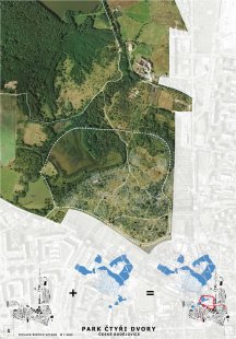
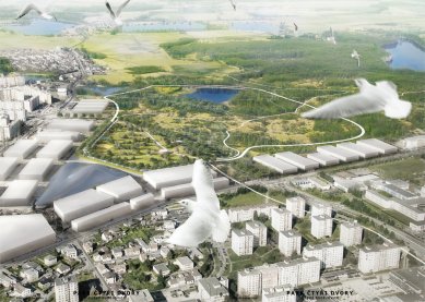
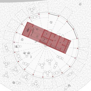
The boundaries of the area addressed for the architectural competition Four Dvory reflect the current state of ownership relations at the site of the former barracks and tank training ground. Within this defined unit, the required building program can be acceptably placed, but the focal point of potential far exceeds its boundaries. The addressed area can be qualitatively assessed by contemplating its possible integration into a network of external spatial relations both within the city and especially within the extensive landscape unit, which represents a unique example of a culturally balanced landscape developed since the Middle Ages. The easily permeable system of more than 50 ponds, connecting forests, meadows, wetlands, and ponds over an area of more than 6,000 hectares offers destinations for active leisure for both city residents and visitors to the area. The future Four Dvory Urban Park has the most suitable prerequisites to become the gateway to the České Budějovice ponds. The area of the future park is located on the boundary of the city and the landscape. This boundary is currently very indistinct, which weakens the area and makes it very fragile in the face of developmental construction plans. The edge of the green wedge is gradually being dulled by metastasizing development. It is highly appropriate to support the regulations of the spatial plan with a clear and definitive form of the boundary of the buildable area.
Embankment
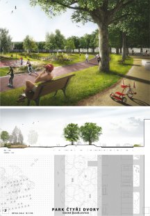
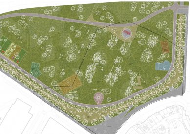
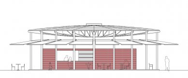
As a defining and simultaneously connecting element, we propose to create a low terrain embankment running along the inner perimeter of the park, tracing the boundary between the city and the landscape. The embankment interprets the motif of the pond dam, which penetrates from the surrounding landscape into the organism of the city. Just as the water dam is the cornerstone of a pond, the proposed embankment will be the initiating element of the new park. Just as the construction body of the embankment combines technological and biotechnological processes, the embankment will become the element that connects the phenomena of the built and natural environment. With age, the embankment will become more robust; people will become accustomed to walking along the 6-meter-wide gravel path on the crown of the embankment lined with a double avenue of oak trees. They will have ample reasons to linger in the shade of the trees and observe the activity of the city street on one side and the life within the park on the other. It will become a place for everyday meetings of dog walkers and Sunday family strolls. A site with a good overview of the center of the action, yet calm, will provide a good backdrop especially for parents with children and elderly citizens; play and exercise elements will be scattered along the length of the embankment, primarily in the widened curves of the promenade, which will strengthen the natural access points from the city at the corners of the park.
Path
A prominent linear element of the oak avenue will help connect the Four Dvory with the nearby Vávrovské ponds. The embankment with the promenade follows the gently rising terrain to the northern edge of the urban park, where it crosses the ring road in the form of a landscape boulevard and creates a basic walking circuit of 4 km by linking the dam of the Mladohaklovský and Velký Vávrovský ponds with the unfinished original dam in the northeastern part of the area.
Cycling Connection
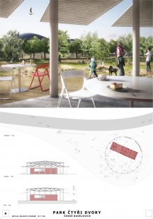
From the elevated promenade, there will be a good view across the entire park area. Along the inner base of the embankment, an inline skating path will run, which in its northern part will utilize the circular cycling path of city-wide significance and create a basic internal inline loop of 1 km. Thanks to the connection to the circular route, it will be possible to effectively link the new urban park with the surrounding housing estates; at the same time, the nearby backbone cycling route along the Vltava, which is part of the international cycling route No. 7 Sun Route (North Cape - Malta), will be connected. The promenade embankment with the inline path running along the park's periphery is also a means of preserving the largest possible free inner area of the park. Along the inline path, all elements of the "urban" program, sports and children's playgrounds, skateparks, which will seamlessly blend with the natural elements, will be distributed.
Strategy
We perceive the construction of the embankment as the cornerstone of the urban park but also as a symbolic threshold between the city and the landscape. Investments made into its realization will enhance the potential of the area beyond the boundaries of the addressed area. For the construction of the earthworks, crushed concrete from the demolition of the barracks facilities or surplus soil generated during the construction of other buildings in the vicinity (road circuit) can be used.
Islands of Wilderness
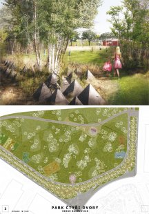
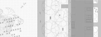
Just as streets and buildings are part of the unchanging structure of the city, the embankment is. Conversely, life within the central area of the park can be very variable over time. The ability to undergo constant change will be perfectly demonstrated by the soft vegetation component due to natural conditions. Within the inner central area of the park, two basic types of vegetation areas will be established, differentiated by species composition with varying management regimes. The base of the inner park area will consist of a mowed resting meadow, from which access will be possible via the inline path from any point of the promenade embankment. Within the resting meadow, irregularly spaced islets referencing the natural forms of the local biotope will be established. These successional areas will generally abut places of natural terrain depressions with reduced management regimes. The frequency, size, and position of these enclaves will be influenced by compositional and operational relationships (views, sight axes, paths), and their extent will change over time. In addition to the larger areas of steppe meadows, local periodic ponds and wetlands will develop here. A certain geometrizing matrix for the system of islets in parts of the future park area is provided by zones constructed from obsolete anti-tank barriers in the footprint of the former barracks, thus regaining their role as a defining element, this time in the interest of protecting the original biotope from park visitors. These areas—sorts of spatial grids—define in the spaces of the urban park true islets of wilderness where natural processes can evolve undisturbed.
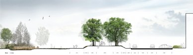
Landscape Boulevard
We will not formalize the network of paths within the inner park area; it will arise organically according to the needs of users, as we can observe in the area today. We view the circular communication not as a necessary evil, but as an element with the potential to establish operational relationships in the area that are acceptable for both vehicular and softer forms of transport.
In this interest, we adjust some parameters of the proposed circular communication:
1/ We level the roadway to the level of the surrounding terrain,
2/ The functional role of eco-ducts will be replaced with a system of at-grade crossings and footbridges,
3/ The ecological function of eco-ducts will be replaced with a system of culverts in the body of the transport structure,
4/ We will expand the central dividing strip and establish an avenue of long-lived trees here.
Riding along the landscape boulevard will allow a good overview of the new park; it will be possible to exit and park at the urban park, as well as utilize the parallel soft path on the outside for parking and access to the Vrbenské ponds.
Landmark
The area on the inner and outer side of the ring road will be connected at the intersection of the ring road with the arms of the promenade embankment by a pair of level crossings with pedestrian and cyclist crossings. Strengthening these connections will be a pedestrian bridge over the ring road placed along the original old road, which in the context of the overall transformation of the area will regain its significance. The bridge will also serve as a lookout point from which it will be possible to overlook the city and pond landscape, becoming a significant visible link between both worlds.
Summary
1/ Clearly define the boundary of the buildable area and public space in a form stemming from the unique cultural and natural context of the area,
2/ Create the edge of the city so that it allows easy connection with the adjacent pond landscape, ensuring the permeability of the area,
3/ Complete the transportation system with a balanced share of vehicular, pedestrian, and cyclist traffic in both radial and concentric directions,
4/ Direct public investments considering the valuable potential of the preserved cultural landscape of the České Budějovice ponds.
Motto
(Edges) can also be understood as seams to which both areas relate and connect through them together. For many people, the edges are a significant organizing characteristic of space, although they are not as important as paths. This partly happens because their role is to hold together coherent areas; for instance, the outline of the city is emphasized by the presence of water or walls.
Kevin Lynch, The Image of the City
Gateway to the Landscape
The boundaries of the area addressed for the architectural competition Four Dvory reflect the current state of ownership relations at the site of the former barracks and tank training ground. Within this defined unit, the required building program can be acceptably placed, but the focal point of potential far exceeds its boundaries. The addressed area can be qualitatively assessed by contemplating its possible integration into a network of external spatial relations both within the city and especially within the extensive landscape unit, which represents a unique example of a culturally balanced landscape developed since the Middle Ages. The easily permeable system of more than 50 ponds, connecting forests, meadows, wetlands, and ponds over an area of more than 6,000 hectares offers destinations for active leisure for both city residents and visitors to the area. The future Four Dvory Urban Park has the most suitable prerequisites to become the gateway to the České Budějovice ponds. The area of the future park is located on the boundary of the city and the landscape. This boundary is currently very indistinct, which weakens the area and makes it very fragile in the face of developmental construction plans. The edge of the green wedge is gradually being dulled by metastasizing development. It is highly appropriate to support the regulations of the spatial plan with a clear and definitive form of the boundary of the buildable area.
Embankment
As a defining and simultaneously connecting element, we propose to create a low terrain embankment running along the inner perimeter of the park, tracing the boundary between the city and the landscape. The embankment interprets the motif of the pond dam, which penetrates from the surrounding landscape into the organism of the city. Just as the water dam is the cornerstone of a pond, the proposed embankment will be the initiating element of the new park. Just as the construction body of the embankment combines technological and biotechnological processes, the embankment will become the element that connects the phenomena of the built and natural environment. With age, the embankment will become more robust; people will become accustomed to walking along the 6-meter-wide gravel path on the crown of the embankment lined with a double avenue of oak trees. They will have ample reasons to linger in the shade of the trees and observe the activity of the city street on one side and the life within the park on the other. It will become a place for everyday meetings of dog walkers and Sunday family strolls. A site with a good overview of the center of the action, yet calm, will provide a good backdrop especially for parents with children and elderly citizens; play and exercise elements will be scattered along the length of the embankment, primarily in the widened curves of the promenade, which will strengthen the natural access points from the city at the corners of the park.
Path
A prominent linear element of the oak avenue will help connect the Four Dvory with the nearby Vávrovské ponds. The embankment with the promenade follows the gently rising terrain to the northern edge of the urban park, where it crosses the ring road in the form of a landscape boulevard and creates a basic walking circuit of 4 km by linking the dam of the Mladohaklovský and Velký Vávrovský ponds with the unfinished original dam in the northeastern part of the area.
Cycling Connection
From the elevated promenade, there will be a good view across the entire park area. Along the inner base of the embankment, an inline skating path will run, which in its northern part will utilize the circular cycling path of city-wide significance and create a basic internal inline loop of 1 km. Thanks to the connection to the circular route, it will be possible to effectively link the new urban park with the surrounding housing estates; at the same time, the nearby backbone cycling route along the Vltava, which is part of the international cycling route No. 7 Sun Route (North Cape - Malta), will be connected. The promenade embankment with the inline path running along the park's periphery is also a means of preserving the largest possible free inner area of the park. Along the inline path, all elements of the "urban" program, sports and children's playgrounds, skateparks, which will seamlessly blend with the natural elements, will be distributed.
Strategy
We perceive the construction of the embankment as the cornerstone of the urban park but also as a symbolic threshold between the city and the landscape. Investments made into its realization will enhance the potential of the area beyond the boundaries of the addressed area. For the construction of the earthworks, crushed concrete from the demolition of the barracks facilities or surplus soil generated during the construction of other buildings in the vicinity (road circuit) can be used.
Islands of Wilderness
Just as streets and buildings are part of the unchanging structure of the city, the embankment is. Conversely, life within the central area of the park can be very variable over time. The ability to undergo constant change will be perfectly demonstrated by the soft vegetation component due to natural conditions. Within the inner central area of the park, two basic types of vegetation areas will be established, differentiated by species composition with varying management regimes. The base of the inner park area will consist of a mowed resting meadow, from which access will be possible via the inline path from any point of the promenade embankment. Within the resting meadow, irregularly spaced islets referencing the natural forms of the local biotope will be established. These successional areas will generally abut places of natural terrain depressions with reduced management regimes. The frequency, size, and position of these enclaves will be influenced by compositional and operational relationships (views, sight axes, paths), and their extent will change over time. In addition to the larger areas of steppe meadows, local periodic ponds and wetlands will develop here. A certain geometrizing matrix for the system of islets in parts of the future park area is provided by zones constructed from obsolete anti-tank barriers in the footprint of the former barracks, thus regaining their role as a defining element, this time in the interest of protecting the original biotope from park visitors. These areas—sorts of spatial grids—define in the spaces of the urban park true islets of wilderness where natural processes can evolve undisturbed.
Landscape Boulevard
We will not formalize the network of paths within the inner park area; it will arise organically according to the needs of users, as we can observe in the area today. We view the circular communication not as a necessary evil, but as an element with the potential to establish operational relationships in the area that are acceptable for both vehicular and softer forms of transport.
In this interest, we adjust some parameters of the proposed circular communication:
1/ We level the roadway to the level of the surrounding terrain,
2/ The functional role of eco-ducts will be replaced with a system of at-grade crossings and footbridges,
3/ The ecological function of eco-ducts will be replaced with a system of culverts in the body of the transport structure,
4/ We will expand the central dividing strip and establish an avenue of long-lived trees here.
Riding along the landscape boulevard will allow a good overview of the new park; it will be possible to exit and park at the urban park, as well as utilize the parallel soft path on the outside for parking and access to the Vrbenské ponds.
Landmark
The area on the inner and outer side of the ring road will be connected at the intersection of the ring road with the arms of the promenade embankment by a pair of level crossings with pedestrian and cyclist crossings. Strengthening these connections will be a pedestrian bridge over the ring road placed along the original old road, which in the context of the overall transformation of the area will regain its significance. The bridge will also serve as a lookout point from which it will be possible to overlook the city and pond landscape, becoming a significant visible link between both worlds.
Summary
1/ Clearly define the boundary of the buildable area and public space in a form stemming from the unique cultural and natural context of the area,
2/ Create the edge of the city so that it allows easy connection with the adjacent pond landscape, ensuring the permeability of the area,
3/ Complete the transportation system with a balanced share of vehicular, pedestrian, and cyclist traffic in both radial and concentric directions,
4/ Direct public investments considering the valuable potential of the preserved cultural landscape of the České Budějovice ponds.
The English translation is powered by AI tool. Switch to Czech to view the original text source.
0 comments
add comment
Related articles
0
16.05.2012 | Park Four Dvory in České Budějovice - competition results
0
16.05.2012 | Architectural competition for Park Čtyři Dvory - first place
0
16.05.2012 | Architectural competition for Park Čtyři Dvory - third place
0
24.02.2012 | Announcement of the Park Čtyři Dvory Competition in České Budějovice